|
|
British life and culture – England, Scotland and Wales
|
UK Facts
|
|
| |
|
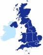
The UK is a country in north-western Europe. It is bordered to the south by the English Channel; to the east by the North Sea; to the west by the Irish Sea and the Atlantic Ocean. |
Countries in the UK: |
England, Scotland, ,Wales ,and
Northern Ireland (also known as Ulster) |
Full Name: |
|
Flag:
The Union Flag |
|
Geographic Coordinates: |
54 00 N, 2 00 W |
Type of Government : |
|
Capital City: |
|
Highest mountain: |
Ben Nevis in Scotland, at 1,343m
(4,406 ft) |
Longest river: |
River Severn, 354 km (220 miles) long.
It rises in Wales and flows to the Bristol Channel.
|
Largest lake: |
|
Deepest Lake: |
Loch Morar in the Highlands of Scotland, 310 m (1,017 ft) deep |
Highest waterfall: |
Eas a’Chual Aluinn, from Glas Bheinn, also in the Highlands of Scotland, with a drop of 200 m (660 ft) |
Deepest cave: |
Ogof Ffynnon Ddu, Powys, Wales, 308 m (1,010 ft) deep |
Most northerly point on the British mainland: |
Dunnet Head, north-east Scotland |
Most southerly point on the British mainland: |
Lizard Point, Cornwall |
Most easterly town in England: |
Lowestoft, Suffolk |
|
Annual mean temperature: |
London 9.7C |
Annual mean rainfall: |
London 753mm |
|
Nationality: |
Noun–Briton(s). Adjective–British. |
Major languages: |
English, Welsh, Irish Gaelic, Scottish Gaelic. |
Main Religion: |
|
Major ethnic groups: |
British, Irish, West Indian, South Asian. |
Total population (1999) |
59,054,800 (2002) |
Annual population growth rate: |
0.29%. (2004 est.) |
Population density per sq.km |
245 |
Population by region: |
Scotland 5,119,000
England 49,753,000
Wales 2,937,000
N. Ireland 1,692,000 |
Top 5 populous cities: |
London 7,285,000
Birmingham 1,018,000
Leeds 725,000
Glasgow 611,000
Sheffield 529,000 |
|
Total land area (sq.km) |
244,110 sq km (94,251 sq mi) |
Area – comparative: |
Slightly smaller than the US state of Oregon
Just under half the size of France
30 times smaller than Australia
|
Coast Line: |
12,429 km |
Length: |
Just under 1,000 km (600 miles) from North to South |
Width: |
About 480 Km from east to west |
Agricultural land: |
|
Forests: |
11% |
Other land use: |
13% |
Natural Resources: |
coal, petroleum, natural gas, tin, limestone, iron ore, salt, clay, chalk, gypsum, lead, silica, arable land .
( Read more) |
|
Average area of home (sq. m): |
97.6 |
Percentage of homes owned: |
68% |
Life expectancy – men
– women |
75
80 |
Passenger cars (millions) |
24 |
|
– Colour TVs
– Satellite/cable TV
– CD players
– Computers
– Cars |
97%
22%
68%
32%
69% |
|
– Food and alcohol
– Clothing
– Rent/mortgage
– Furniture
– Medical care
– Transport
– Education & leisure |
27%
6%
14%
5%
1%
10%
13% |
Household savings |
3% |
|
|
|
 © Copyright – please read © Copyright – please read
All the materials on these pages are free for homework and classroom use only. You may not redistribute, sell or place the content of this page on any other website or blog without written permission from the . |
© Copyright 2014
is the creator of the Woodlands Resources section of the Woodlands Junior website.
The two websites projectbritain.com and primaryhomeworkhelp.co.uk are the new homes for the Woodlands Resources.
left Woodlands in 2003 to work in Kent schools as an ICT Consultant.
She now teaches computers at The Granville School and St. John’s Primary School in Sevenoaks Kent.
Follow on Twitter
Woodlands Junior Homework Help new website
|
|
 Project Britain